Breadcrumb
- Home/
- Research/
- Research projects/
- ArchEthno, from raw ethnographic materials to data

ArchEthno is a set of digital tools still in progress, which allows the ethnographer to structure her raw materials, transform them into data answering a scientific question, and provide each data and metadata with a level of confidentiality.
ArchEthno has been conceived to overcome a virulent debate about ethnographic enquiries. Because ethnography is based on personal encounters and an engagement between the Observers and the Observered, the confidentiality of ethnographic data, justified by a right to privacy, contributes to suspicions concerning the scientific accuracy of qualitative methods in social sciences.
Built on an experience conducted by Agnès Tricoche and Florence Weber between 2014 and 2017, and the decisive intervention of Carlo-Maria Zwölf in 2018, we have built a data and metadata structuring dictionary, at the principle of the software named ArchEthno2020. This software, with the financial support of PSL Valorisation and the
help of CNRS (Centre Maurice Halbwachs), allows researchers to structure their raw materials to transform them into data that answers a scientific question, while deciding for each data/metadata whether it will be open access or restricted access to authorized persons. The tool comes in two parts: ArchEditor, which is already functional, allows the self-searching of materials; ArchWeb, a documentary platform for the web, will allow the consultation of the self-searched data while respecting the rules of confidentiality defined by the data producers.
Collective ethnography faces two recurrent difficulties: young collaborators fear data pilferage, collecting data must respect privacy of interviewees and interviewers. That is why a scientific team (photographers Jean-Robert Dantou and Mathias Nouël, ethnographers Jean-Marc Goudet, Paco Rapin and Olivia Vieujean, architect-urbanist and geographer Alix de la Gaignonnière, as well as Preciosa Dombele and Mélina Gautrand, in charge of data management) decided to set up, during the Atelier La Souterraine, the different steps allowing to select among the materials those that will be shared within the research team and, eventually, with researchers interested in revisiting the survey, and those that will be published at the time of the restitution to the respondents, then for a scientific public and, eventually, for a non-specialized public.

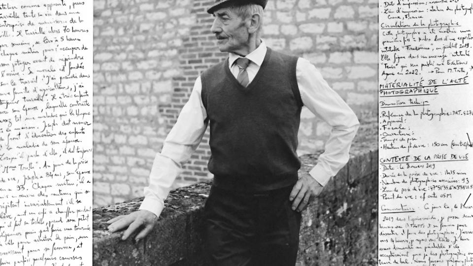
The mass of so defined data/metadata is organized in a digital architecture built around one or more scientific questions. The consultation of unpublished data will take place at the library of the École normale supérieure. We can already note the important place that photography will play in the visualization interface, chosen both for its formal qualities and for its evocative power, and equipped with all the elements that allow us to understand the shooting relationship, the investigative relationship, what photography gives to see and what it leaves out of the picture.
The La Souterraine workshop, which focused on the spatial translation of the increase of social inequalities in contemporary France, allowed us to discover another aspect of data visualization: the map. The maps have a double function in the survey: they are a tool for reflection on the progress of the ethnographic survey, and they are also a tool for contextualizing the spaces studied.
As the software was being designed, it seemed to us that it could arouse the interest of other users. It aims to give the researcher control over the process of organizing his or her materials, thus giving free rein to his or her inventiveness as he or she tries things out.
Team
Directors
- Florence Weber, professeure des Universités à l’ENS, département de Sciences sociales, CMH
- Agnès Tricoche, ingénieure d’études au CNRS, AOROC
Collaborators
- Jean-Robert Dantou, chercheur doctoral SACRe, moniteur au département Arts de l’ENS, conception des liens entre données photographiques et ethnographiques
- Jean-Marc Goudet, chercheur doctoral CMH, sociologue et médecin de santé publique, conception des liens entre matériaux de terrain et données scientifiques
- Jose Sastre, informaticien indépendant, aide à la conception du logiciel
- Alix Sportich, chercheur doctoral, moniteur au département Géographie de l’ENS, architecte, urbaniste, conception des données cartographiques
- Carlo Zwölf, ingénieur de recherches à l’Observatoire de Paris, LERMA, conception de l’architecture informatique basée sur des dictionnaires de concepts et du dictionnaire de structuration des données